Showing posts with label History. Show all posts
Harappa (2600–1900 BC)

Harappa (2600–1900 BC)

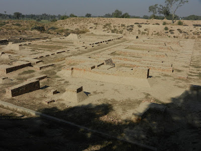
                                  This is a photo of a monument in Pakistan identified as the

Harappa (Punjabi pronunciation: [ɦəɽəppaː]; Urdu/Punjabi: ہڑپّہ‬) is an archaeological site in Punjab, Pakistan, about 24 km (15 mi) west of Sahiwal. The site takes its name from a modern village located near the former course of the Ravi River which now runs 8 km (5.0 mi) in north. The current village of Harappa is less than 1 km (0.62 mi) from the ancient site. Although modern Harappa has a legacy railway station from the period of the British Raj, it is today just a small crossroads town of population 15,000.
The site of the ancient city contains the ruins of a Bronze Age fortified city, which was part of the Indus Valley Civilization centered in Sindh and the Punjab, and then the Cemetery H culture.The city is believed to have had as many as 23,500 residents and occupied about 150 hectares (370 acres) with clay brick houses at its greatest extent during the Mature Harappan phase (2600–1900 BC), which is considered large for its time.Per archaeological convention of naming a previously unknown civilization by its first excavated site, the Indus Valley Civilization is also called the Harappan Civilization.The ancient city of Harappa was heavily damaged under British rule, when bricks from the ruins were used as track ballast in the construction of the Lahore–Multan Railway. In 2005, a controversial amusement park scheme at the site was abandoned when builders unearthed many archaeological artifacts during the early stages of building work. A plea from the Pakistani archaeologist Mohit Prem Kumar to the Ministry of Culture resulted in a restoration of the site.
History
Map showing the sites and extent of the Indus Valley Civilisation. Harappa was the center of one of the core regions of the Indus Valley Civilization, located in central Punjab. The Harappan architecture and Harappan Civilization was one of the most developed in the old Bronze Age.
The Harappan Civilization has its earliest roots in cultures such as that of Mehrgarh, approximately 6000 BC. The two greatest cities, Mohenjo-daro and Harappa, emerged circa 2600 BC along the Indus River valley in Punjab and Sindh.The civilization, with a possible writing system, urban centers, and diversified social and economic system, was rediscovered in the 1920s also after excavations at Mohenjo-daro in Sindh near Larkana, and Harappa, in west Punjab south of Lahore. A number of other sites stretching from the Himalayan foothills in east Punjab, India in the north, to Gujarat in the south and east, and to Pakistani Balochistan in the west have also been discovered and studied. Although the archaeological site at Harappa was damaged in 1857 when engineers constructing the Lahore-Multan railroad (as part of the Sind and Punjab Railway), used brick from the Harappa ruins for track ballast, an abundance of artifacts have nevertheless been found.The bricks discovered were made of red sand, clay, stones and were baked at very high temperature. As early as 1826 Harappa, located in west Punjab, attracted the attention of a British officer in India, who gets credit for preliminary excavations in Harappa.
Culture and economy
The Indus Valley civilization was mainly an urban culture sustained by surplus agricultural production and commerce, the latter including trade with Sumer in southern Mesopotamia. Both Mohenjo-Daro and Harappa are generally characterized as having "differentiated living quarters, flat-roofed brick houses, and fortified administrative or religious centers." Although such similarities have given rise to arguments for the existence of a standardized system of urban layout and planning, the similarities are largely due to the presence of a semi-orthogonal type of civic layout, and a comparison of the layouts of Mohenjo-Daro and Harappa shows that they are in fact, arranged in a quite dissimilar fashion.The weights and measures of the Indus Valley Civilization, on the other hand, were highly standardized, and conform to a set scale of gradations. Distinctive seals were used, among other applications, perhaps for identification of property and shipment of goods. Although copper and bronze were in use, iron was not yet employed. "Cotton was woven and dyed for clothing; wheat, rice, and a variety of vegetables and fruits were cultivated; and a number of animals, including the humped bull, were domesticated," as well as "fowl for fighting". Wheel-made pottery—some of it adorned with animal and geometric motifs—has been found in profusion at all the major Indus sites. A centralized administration for each city, though not the whole civilization, has been inferred from the revealed cultural uniformity; however, it remains uncertain whether authority lay with a commercial oligarchy. Harappans had many trade routes along the Indus River that went as far as the Persian Gulf, Mesopotamia, and Egypt. Some of the most valuable things traded were carnelian and lapis lazuli.

Archaeology
A map of the excavations at Harappa
Miniature Votive Images or Toy Models from Harappa, ca. 2500. Hand-modeled terra-cotta figurines with polychromy.

The excavators of the site have proposed the following chronology of Harappa's occupation:
Ravi Aspect of the Hakra phase, c. 3300 – 2800 BC.
Kot Dijian (Early Harappan) phase, c. 2800 – 2600 BC.
Harappan Phase, c. 2600 – 1900 BC.
Transitional Phase, c. 1900 – 1800 BC.
Late Harappan Phase, c. 1800 – 1300 BC.


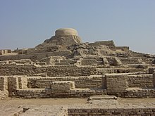


Mohenjo-Daro 2500 BCE To 3000 BCE

Mohenjo-Daro 2500 BCE To 3000 BCE

Mohenjo-daro (/moʊˌhɛndʒoʊ ˈdɑːroʊ/; Sindhi: موئن جو دڙو‎, meaning 'Mound of the Dead Men' Urdu: موئن جو دڑو‬‎ [muˑənⁱ dʑoˑ d̪əɽoˑ]) is an archaeological site in the province of Sindh, Pakistan. Built around 2500 BCE, it was one of the largest settlements of the ancient Indus Valley civilization, and one of the world's earliest major cities, contemporaneous with the civilizations of ancient Egypt, Mesopotamia, Minoan Crete, and Norte Chico. Mohenjo-daro was abandoned in the 19th century BCE as the Indus Valley Civilization declined, and the site was not rediscovered until the 1920s. Significant excavation has since been conducted at the site of the city, which was designated a UNESCO World Heritage Site in 1980.The site is currently threatened by erosion and improper restoration.
Etymology
Mohenjo-daro, the modern name for the site, has been variously interpreted as "Mound of the Dead Men" in Sindhi, and as "Mound of Mohan" (where Mohan is Krishna).The city's original name is unknown. Based on his analysis of a Mohenjo-daro seal, Iravatham Mahadevan speculates that the city's ancient name could have been Kukkutarma ("the city [-rma] of the cockerel [kukkuta]").Cock-fighting may have had ritual and religious significance for the city, with domesticated chickens bred there for sacred purposes, rather than as a food source. Mohenjo-daro may also have been a point of diffusion for the eventual worldwide domestication of chickens.
Location
Map showing the major sites and theorised extent of the Indus Valley Civilisation, including the location of the Mohenjo-daro site
Mohenjo-daro is located west of the Indus River in Larkana District, Sindh, Pakistan, in a central position between the Indus River and the Ghaggar-Hakra River. It is sited on a Pleistocene ridge in the middle of the flood plain of the Indus River Valley, around 28 kilometres (17 mi) from the town of Larkana.The ridge was prominent during the time of the Indus Valley Civilization, allowing the city to stand above the surrounding flood, but subsequent flooding has since buried most of the ridge in silt deposits. The Indus still flows east of the site, but the Ghaggar-Hakra riverbed on the western side is now dry.
Historical context
Mohenjo-daro was built in the 26th century BCE.It was one of the largest cities of the ancient Indus Valley Civilization, also known as the Harappan Civilization,which developed around 3,000 BCE from the prehistoric Indus culture. At its height, the Indus Civilization spanned much of what is now Pakistan and North India, extending westwards to the Iranian border, south to Gujarat in India and northwards to an outpost in Bactria, with major urban centers at Harappa, Mohenjo-daro, Lothal, Kalibangan, Dholavira and Rakhigarhi. Mohenjo-daro was the most advanced city of its time, with remarkably sophisticated civil engineering and urban planning.When the Indus civilization went into sudden decline around 1900 BCE, Mohenjo-daro was abandoned.
Rediscovery and excavation


The ruins of the city remained undocumented for around 3,700 years until R. D. Banerji, an officer of the Archaeological Survey of India, visited the site in 1919–20, identifying the Buddhist stupa (150–500 CE) known to be there and finding a flint scraper which convinced him of the site's antiquity. This led to large-scale excavations of Mohenjo-daro led by Kashinath Narayan Dikshit in 1924–25, and John Marshall in 1925–26.In the 1930s, major excavations were conducted at the site under the leadership of Marshall, D. K. Dikshitar and Ernest Mackay. Further excavations were carried out in 1945 by Ahmad Hasan Dani and Mortimer Wheeler. The last major series of excavations were conducted in 1964 and 1965 by Dr. George F. Dales. After 1965 excavations were banned due to weathering damage to the exposed structures, and the only projects allowed at the site since have been salvage excavations, surface surveys, and conservation projects. However, in the 1980s, German and Italian survey groups led by Dr. Michael Jansen and Dr. Maurizio Tosi used less invasive archeological techniques, such as architectural documentation, surface surveys, and localized probing, to gather further information about Mohenjo-daro.A dry core drilling conducted in 2015 by Pakistan's National Fund for Mohenjo-daro revealed that the site is larger than the unearthed area.

Mohenjo-Daro Pictures Gallery

View of the site's Great Bath, showing the surrounding urban layout
"The Dancing Girl", a bronze statuette at the National Museum, New Delhi
The Great Bath
Regularity of streets and buildings suggests the influence of ancient urban planning in Mohenjo-daro's construction.
"The Priest-King", a seated stone sculpture at the National Museum, Karachi
Excavation of the city revealed very tall wells (left), which it seems were continually built up as flooding and rebuilding raised the elevation of street level.


Dead Sea

Dead Sea

The Dead Sea is Sea of Salt lake bordered by Jordan to the east and Israel and Palestine to the west. Its surface and shores are 430.5 metres (1,412 ft) below sea level, Earth's lowest elevation on land. The Dead Sea is 304 m (997 ft) deep, the deepest hypersaline lake in the world. With a salinity of 342 g/kg, or 34.2%, (in 2011), it is 9.6 times as salty as the ocean and one of the world's saltiest bodies of water.[7] This salinity makes for a harsh environment in which plants and animals cannot flourish, hence its name. The Dead Sea's main, northern basin is 50 kilometres (31 mi) long and 15 kilometres (9 mi) wide at its widest point.It lies in the Jordan Rift Valley, and its main tributary is the Jordan River.
The Dead Sea has attracted visitors from around the Mediterranean basin for thousands of years. It was one of the world's first health resorts (for Herod the Great), and it has been the supplier of a wide variety of products, from asphalt for Egyptian mummification to potash for fertilisers. People also use the salt and the minerals from the Dead Sea to create cosmetics and herbal sachets.
The Dead Seawater has a density of 1.24 kg/litre, which makes swimming similar to floating.
The Dead Sea is receding at an alarming rate. Multiple canals and pipelines were proposed to reduce its recession, which had begun causing many problems. The Red Sea–Dead Sea Water Conveyance project, carried out by Jordan, will provide water to neighbouring countries, while the brine will be carried to the Dead Sea to help stabilise its levels. The first phase of the project is scheduled to begin in 2018 and be completed in 2021
There are two contending hypotheses about the origin of the low elevation of the Dead Sea. The older hypothesis is that the Dead Sea lies in a true rift zone, an extension of the Red Sea Rift, or even of the Great Rift Valley of eastern Africa. A more recent hypothesis is that the Dead Sea basin is a consequence of a "step-over" discontinuity along the Dead Sea Transform, creating an extension of the crust with consequent subsidence
Approximately two million years ago,[citation needed] the land between the Rift Valley and the Mediterranean Sea rose to such an extent that the ocean could no longer flood the area. Thus, the long lagoon became a landlocked lake. The Sedom Lagoon extended at its maximum from the Sea of Galilee in the north to somewhere around 50 km (30 mi) south of the current southern end of the Dead Sea, and the subsequent lakes obviously never surpassed this expanse. The Hula Depression was never part of any of these water bodies due to its higher elevation and the high threshold of the Korazim block separating it from the Sea of Galilee basin.The first prehistoric lake to follow the Sedom Lagoon is named Lake Amora, followed by Lake Lisan and finally by the Dead Sea.[17] The water levels and salinity of these lakes have either risen or fallen as an effect of the tectonic dropping of the valley bottom, and due to climate variation. As the climate became more arid, Lake Lisan finally shrank and became saltier, leaving the Dead Sea as its last remainder,From 70,000 to 12,000 years ago, the lake's level was 100 m (330 ft) to 250 m (820 ft) higher than its current level. This lake, Lake Lisan, fluctuated dramatically, rising to its highest level around 26,000 years ago, indicating a very wet climate in the Near East. Around 10,000 years ago, the lake's level dropped dramatically, probably to even lower than today's. During the last several thousand years, the lake has fluctuated approximately 400 m (1,300 ft), with some significant drops and rises. Current theories as to the cause of this dramatic drop in levels rule out volcanic activity; therefore, it may have been a seismic event.

The planned Red Sea–Dead Sea Water Conveyance, whose first phase will begin construction in 2018, will work towards stabilizing the falling levels of the Dead Sea.

                                              Views in 1972, 1989, and 2011 compared

                                                The dwindling water level of the Dead Sea


British Empire

British Empire

British Empire
 comprised the dominions, colonies, protectorates, mandates and other territories ruled or administered by the United Kingdom and its predecessor states. It originated with the overseas possessions and trading posts established by Englandbetween the late 16th and early 18th centuries. At its height, it was the largest empire in history and, for over a century, was the foremost global power.By 1913, the British Empire held sway over 412 million people, 23% of the world population at the time,and by 1920, it covered 35,500,000 km2 (13,700,000 sq mi), 24% of the Earth's total land area.As a result, its political, legal, linguisticand cultural legacy is widespread. At the peak of its power, the phrase "the empire on which the sun never sets" was often used to describe the British Empire, because its expanse around the globe meant that the sun was always shining on at least one of its territories.
During the Age of Discovery in the 15th and 16th centuries, Portugal and Spain pioneered European exploration of the globe, and in the process established large overseas empires. Envious of the great wealth these empires generated,England, France, and the Netherlands began to establish colonies and trade networks of their own in the Americas and Asia. A series of wars in the 17th and 18th centuries with the Netherlands and France left England and then, following union between England and Scotland in 1707, Great Britain, the dominant colonial power in North America. It then became the dominant power in the Indian subcontinent after the East India Company's conquest of Mughal Bengal at the Battle of Plassey in 1757.
The independence of the Thirteen Colonies in North America in 1783 after the American War of Independence caused Britain to lose some of its oldest and most populous colonies. British attention soon turned towards Asia, Africa, and the Pacific. After the defeat of France in the Revolutionary and Napoleonic Wars (1792–1815), Britain emerged as the principal naval and imperial power of the 19th century.Unchallenged at sea, British dominance was later described as Pax Britannica ("British Peace"), a period of relative peace in Europe and the world (1815–1914) during which the British Empire became the global hegemon and adopted the role of global policeman. In the early 19th century, the Industrial Revolution began to transform Britain; so that by the time of the Great Exhibition in 1851, the country was described as the "workshop of the world".The British Empire expanded to include most of India, large parts of Africa and many other territories throughout the world. Alongside the formal control that Britain exerted over its own colonies, its dominance of much of world trade meant that it effectively controlled the economies of many regions, such as Asia and Latin America.
During the 19th century, Britain's population increased at a dramatic rate, accompanied by rapid urbanisation, which caused significant social and economic stresses.To seek new markets and sources of raw materials, the British government under Benjamin Disraeli initiated a period of imperial expansion in Egypt, South Africa, and elsewhere. Canada, Australia, and New Zealand became self-governing dominions.
By the start of the 20th century, Germany and the United States had begun to challenge Britain's economic lead. Subsequent military and economic tensions between Britain and Germany were major causes of the First World War, during which Britain relied heavily upon its empire. The conflict placed enormous strain on the military, financial and manpower resources of Britain. Although the British Empire achieved its largest territorial extent immediately after World War I, Britain was no longer the world's pre-eminent industrial or military power. In the Second World War, Britain's colonies in Southeast Asia were occupied by Japan. Despite the final victory of Britain and its allies, the damage to British prestige helped to accelerate the decline of the empire. India, Britain's most valuable and populous possession, achieved independence as part of a larger decolonisation movement in which Britain granted independence to most territories of the empire. The transfer of Hong Kong to China in 1997 marked for many the end of the British Empire.Fourteen overseas territories remain under British sovereignty.
After independence, many former British colonies joined the Commonwealth of Nations, a free association of independent states. The United Kingdom is now one of 16 Commonwealth nations, a grouping known informally as the Commonwealth realms, that share a monarch, Queen Elizabeth II.
"First" British Empire (1583–1783)
In 1578, Elizabeth I granted a patent to Humphrey Gilbert for discovery and overseas exploration. That year, Gilbert sailed for the Caribbean with the intention of engaging in piracy and establishing a colony in North America, but the expedition was aborted before it had crossed the Atlantic.In 1583, he embarked on a second attempt, on this occasion to the island of Newfoundland whose harbour he formally claimed for England, although no settlers were left behind. Gilbert did not survive the return journey to England, and was succeeded by his half-brother, Walter Raleigh, who was granted his own patent by Elizabeth in 1584. Later that year, Raleigh founded the Roanoke Colony on the coast of present-day North Carolina, but lack of supplies caused the colony to fail.
In 1603, James VI, King of Scots, ascended (as James I) to the English throne and in 1604 negotiated the Treaty of London, ending hostilities with Spain. Now at peace with its main rival, English attention shifted from preying on other nations' colonial infrastructures to the business of establishing its own overseas colonies.The British Empire began to take shape during the early 17th century, with the English settlement of North America and the smaller islands of the Caribbean, and the establishment of joint-stock companies, most notably the East India Company, to administer colonies and overseas trade. This period, until the loss of the Thirteen Colonies after the American War of Independence towards the end of the 18th century, has subsequently been referred to by some historians as the "First British Empire".
Map of United Kingdom ( British Empire)
Flag of United Kindom

Sleights UK

Sleights UK


Sleights railway station

Sleights railway station is in the village of Sleights in North YorkshireEngland. It is on the Esk Valley Line and is operated by Northern who provide all of the station's passenger services. The station serves the village of Sleights, located behind the station, and the hamlet of Briggswath on the opposite side of the valley across the River Esk.
Sleights station was designed by George Townsend Andrews and opened in 1846. It used to have two platforms for up and down line working, but in common with the other stations between Grosmont and Whitby, this was reduced to single track working in the mid eighties when the second track was lifted and Sleights signal box closed. Trains now stop at the former Up line platform where the main station buildings including the Station Master's house are now a private residence. The former down platform used to have a wooden waiting shed and store; this building was recovered by the North Yorkshire Moors Railway and re-erected on the extended down platform at Grosmont. Behind the down platform was a small goods yard with a single siding.
At one end of the platform, a footpath carries passengers over the River Esk to Briggswath on a small box girder bridge, while at the other the A169 towers over the railway and river on a bridge opened on 26 January 1937. The site of the modern day footpath used to be a level crossing carrying the main Whitby-Pickering road to a stone bridge over the Esk, before this was washed away during floods in 1930. Next to the crossing a 19th-century brick built signal box remains, now unused and boarded up.

                                      Sleights


American History

American History

                                 Pre-Columbian Era


It is not definitively known how or when the Native Americans first settled the Americas and the present-day United States. The prevailing theory proposes that people migrated from Eurasia across Beringia, a land bridge that connected Siberia to present-day Alaska during the Ice Age, and then spread southward throughout the Americas. This migration may have begun as early as 30,000 years ago[1] and continued through to about 10,000+ years ago, when the land bridge became submerged by the rising sea level caused by the ending of the last glacial period.[2]These early inhabitants, called Paleoamericans, soon diversified into many hundreds of culturally distinct nations and tribes.
The pre-Columbian era incorporates all period subdivisions in the history and prehistory of the Americas before the appearance of significant European influences on the American continents, spanning the time of the original settlement in the Upper Paleolithic period to European colonization during the early modern period. While technically referring to the era before Christopher Columbus' voyages of 1492 to 1504, in practice the term usually includes the history of American indigenous cultures until they were conquered or significantly influenced by Europeans, even if this happened decades or even centuries after Columbus' initial landing.


This map shows the approximate location of the ice-free corridor and specific Paleoindian sites (Clovis theory).


ANCIENT EMPIRES IN INDIA

ANCIENT EMPIRES IN INDIA

                     ANCIENT EMPIRES AND RELIGIOUS MOVEMENTS

The east not only produced the first Indian empire, it also gave rise to new religious movements, Buddhism and Jainism. Both flourished in a region which was in close contact with the Gangetic civilization of the west but had not been subjected to the slow growth of its royal institutions and courtly Brahminism. Thus, entirely new forms of organisation evolved, like the monastic order (sangha) of the Buddhists and the imperial control of trade and land revenue which provided the resources for a greater military potential than any of the Aryan kingdoms could have achieved. Rice was one of the most important resources of this region, because the eastern Gangetic basin was the largest region of India to fulfill the necessary climatic conditions. Well-organized Buddhist monasteries were initially better suited for the cultural penetration of this vast eastern region than small groups of brahmins would have been. Monasteries, of course, required more sustained support than such small groups of Brahmins, but this was no problem in this rice bowl of India. The new empire of the east, with its centre in Magadha to the south of the river Ganga, first vanquished the tribal republics in the Trans-Gandak region to the north of the Ganga and then the Aryan kingdoms of the west, showing little respect for their traditions and finally imposing a new ideology of its own. But this empire in turn succumbed to internal conflicts and the onslaught of new invaders who came from the north, where the Aryans had come from more than a millennium earlier. The new invaders arrived when ecological conditions were improving once more in northern India. They also had the benefit of finding readily available imperial patterns which they could adopt very quickly. Aryan royal institutions had taken centuries to mature in the relatively isolated Gangetic basin. In a world of closer connections and wider horizons where Hellenistic, Iranian and Indian models of governance and ritual sovereignty were known to all, a new invader could leap from the darkness of an unrecorded nomadic past to the limelight of imperial history within a relatively short period. Shakas and Kushanas swept in this way across northern India. Their short-lived imperial traditions embodied a syncretism of several available patterns of legitimation. They also adopted Hinduism, not the Vedic tradition but rather the more popular cults of Vishnu and Shiva. The waves of imperial grandeur which swept across northern India then stimulated the south. But when the first great indigenous dynasty of the south, the Shatavahanas, emerged they did not follow the syncretism of the northern empires but harked back to the tradition of the small Aryan kingdoms of the Gangetic civilisation. The great horse sacrifice was celebrated once more by a Shatavahana king, but the meaning of this ritual was now very different from that of the old flexible test of royal authority. It was now a great symbolic gesture of a mighty king whose

                                 Excavated ruins of Mohenjo-daro,with the Great Bath in the front.

                                               History map of the Indus Valley civilization

                                                                 Indian Map in 1567


Copyright © 2015. Waqas4s
Blogger Templates