Showing posts with label Traveling. Show all posts
Khewra Salt Mine

Khewra Salt Mine


The Khewra Salt Mine (or Mayo Salt Mine) is located in Khewra, north of Pind Dadan Khan,an administrative subdivision of Jhelum District, Punjab Region, Pakistan, which rises from the Indo-Gangetic Plain.[2] It is Pakistan's largest, the world's 2nd largest  and the oldest salt mine in the world. It is a major tourist attraction, drawing up to 250,000 visitors a year. Its history dates back to its discovery by Alexander's troops in 320 BC, but it started trading in the Mughal era.The main tunnel at ground level was developed by Dr. H. Warth, a mining engineer, in 1872 during British rule. After independence, the Pakistan Mineral Development Corporation took over the mine, which still remains the largest source of salt in the country, producing more than 350,000 tons per annum of about 99% pure halite. Estimates of the reserves of salt in the mine vary from 82 million tons to 600 million tons.
History
The Khewra Salt Mine is also known as Mayo Salt Mine, in honour of Lord Mayo, who visited it as Viceroy of India.The mine is a part of a salt range that originated about 800 million years ago, when evaporation of a shallow sea followed by geological movement formed a salt range that stretched for about 300 kilometers (185 miles).
The salt reserves at Khewra were discovered when Alexander the Great crossed the Jhelum and Mianwali region during his Indian campaign. The mine was discovered, however, not by Alexander, nor by his allies, but by his army's horses, when they were found licking the stones.Ailing horses of his army also recovered after licking the rock salt stones.During the Mughal era the salt was traded in various markets, as far away as Central Asia.On the downfall of the Mughal empire, the mine was taken over by Sikhs. Hari Singh Nalwa, the Sikh Commander-in-Chief, shared the management of the Salt Range with Gulab Singh, the Raja of Jammu. The former controlled the Warcha mine, while the latter held Khewra. The salt quarried during Sikh rule was both eaten and used as a source of revenue.
In 1872, some time after they had taken over the Sikhs' territory, the British developed the mine further.They found the mining to have been inefficient, with irregular and narrow tunnels and entrances that made the movement of labourers difficult and dangerous. The supply of water inside the mine was poor, and there was no storage facility for the mined salt. The only road to the mine was over difficult, rocky terrain. To address these problems the government levelled the road, built warehouses, provided a water supply, improved the entrances and tunnels, and introduced a better mechanism for excavation of salt. Penalties were introduced to control salt smuggling.
While working with Geological Survey of India in the 1930s and 1940s, Birbal Sahni found evidence of angiosperms, gymnosperms and insects inside the mine which he regarded as originating from the Eocene period, but which Michael Cremo alleged originated from the Cambrian period.However, Cremo's opinion is not supported by contemporary geologists.
Location
Khewra Salt Mine is situated in Pind Dadan Khan Tehsil of Jhelum District. Located about 160 km (100 miles) from Islamabad and Lahore, it is accessed via the M2 motorway, about 30 kilometers (20 miles) off the Lilla interchange while going towards Pind Dadan Khan on the Lilla road.The mine is in mountains that are part of a salt range, a mineral-rich mountain system extending about 200 km from the Jhelum river south of Pothohar Plateau to where the Jhelum river joins the Indus river.Khewra mine is about 288 meters (945 feet) above sea leve and about 730 meters (2400 feet) into the mountain from the mine entrance. The underground mine covers an area of 110 km2 (43 sq. miles)
Tourism
Khewra Salt Mine is a major tourist attraction, with around 250,000 visitors a year,earning it considerable revenue.Visitors are taken into the mine on a train.There are numerous pools of salty water inside. The Badshahi Mosque was built in the mining tunnels with multi-colored salt bricks about fifty years ago.Other artistic carvings in the mine include a replica of Minar-e-Pakistan, a statue of Allama Iqbal, an accumulation of crystals that form the name of Muhammad in Urdu script, a model of the Great Wall of China and another of the Mall Road of Murree. In 2003 two phases of development of tourist facilities and attractions were carried out, at a total cost of 9 million rupees. A clinical ward with 20 beds was established in 2007, costing 10 million rupees,for the treatment of asthma and other respiratory diseases using salt therapy.The "Visit Pakistan Year 2007" event included a train safari visit of Khewra Salt Mine.In February 2011 Pakistan railways started operating special trains for tourists from Lahore and Rawalpindito Khewra. For this purpose the railway station of Khewra was refurbished with the help of a private firm.
Other visitor attractions in the mine include the 75-meter-high (245 feet) Assembly Hall; Pul-Saraat, a salt bridge with no pillars over a 25-meters-deep (80-foot-deep) brine pond; Sheesh Mahal (Palace of Mirrors), where salt crystals are light pink; and a cafe.

Khewra Salt Mine Pictuer Gallery

Crystal Deposits exhibit can be seen on the 7th floor (1 floor below the entrance level) ... only certain guides have access/key to the exhibit. Check first to see who can show you this place as this is best part of the tour 
                        A small masjid made of salt bricks inside the Khewra salt mine complex
                                Students of the Mine Survey Institute gathered inside a tunnel
There is a beautiful mosque that has been built inside the Khewra Salt Mines in Pakistan, known as the world's second largest salt mine.
                             Rock salt makes for some beautiful texture on the walls and ceiling.
It is said that these rooms were mined during the Mughal era.
Crystal Valley, a tunnel with crystals in the wall and roof, illuminated by colorful lights.
Artistic work with rock salt.


Mount Everest

Mount Everest


Mount Everest, known in Nepali as Sagarmāthā and in Tibetan as Chomolungma, is Earth's highest mountain above sea level, located in the Mahalangur Himal sub-range of the Himalayas. The international border between China (Tibet Autonomous Region) and Nepal (Province No. 1) runs across its summit point.
The current official elevation of 8,848 m (29,029 ft), recognised by China and Nepal, was established by a 1955 Indian survey and subsequently confirmed by a Chinese survey in 1975.n 2005, China remeasured the rock height of the mountain, with a result of 8844.43 m. There followed an argument between China and Nepal as to whether the official height should be the rock height (8,844 m., China) or the snow height (8,848 m., Nepal). In 2010, an agreement was reached by both sides that the height of Everest is 8,848 m, and Nepal recognises China's claim that the rock height of Everest is 8,844 m.
In 1865, Everest was given its official English name by the Royal Geographical Society, upon a recommendation by Andrew Waugh, the British Surveyor General of India. As there appeared to be several different local names, Waugh chose to name the mountain after his predecessor in the post, Sir George Everest, despite George Everest's objections.
Mount Everest attracts many climbers, some of them highly experienced mountaineers. There are two main climbing routes, one approaching the summit from the southeast in Nepal (known as the "standard route") and the other from the north in Tibet. While not posing substantial technical climbing challenges on the standard route, Everest presents dangers such as altitude sickness, weather, and wind, as well as significant hazards from avalanches and the Khumbu Icefall. As of 2017, nearly 300 people have died on Everest, many of whose bodies remain on the mountain.The first recorded efforts to reach Everest's summit were made by British mountaineers. As Nepal did not allow foreigners into the country at the time, the British made several attempts on the north ridge route from the Tibetan side. After the first reconnaissance expedition by the British in 1921 reached 7,000 m (22,970 ft) on the North Col, the 1922 expedition pushed the north ridge route up to 8,320 m (27,300 ft), marking the first time a human had climbed above 8,000 m (26,247 ft). Seven porters were killed in an avalanche on the descent from the North Col. The 1924 expedition resulted in one of the greatest mysteries on Everest to this day: George Mallory and Andrew Irvine made a final summit attempt on 8 June but never returned, sparking debate as to whether or not they were the first to reach the top. They had been spotted high on the mountain that day but disappeared in the clouds, never to be seen again, until Mallory's body was found in 1999 at 8,155 m (26,755 ft) on the north face. Tenzing Norgay and Edmund Hillarymade the first official ascent of Everest in 1953, using the southeast ridge route. Tenzing had reached 8,595 m (28,199 ft) the previous year as a member of the 1952 Swiss expedition. The Chinese mountaineering team of Wang Fuzhou, Gonpo, and Qu Yinhua made the first reported ascent of the peak from the north ridge on 25 May 1960.

Climber at the summit wearing an oxygen mask
Everest base camp
Mt. Everest, seen from Tingri, a small village on the Tibetan plateau at around 4050m above sea level.
Everest in September 2006, what can be seen here is how white all the mountains are from snowfall. The increased snowfall in the autumn has made it popular for ski/snow boarding but the increased risk of avalanche from all the snow does not benefit mountaineering


The location of the fatal ice avalanche on the 2014 route, and the revised 2015 route through the Khumbu.
Mount Everest, 2014
Annotated image of Everest and surroundings as seen from Gokyo Ri. Changtse, Nirekha, Everest, Lobuche West, Cho La, Nuptse, Lhotse, Lobuche, Island Peak

K2

K2


K2 also known as Mount Godwin-Austen or Chhogori, at 8,611 metres (28,251 ft) above sea level, is the second highest mountain in the world, after Mount Everest, at 8,848 metres (29,029 ft). It is located on the China–Pakistan border between Baltistan, in the Gilgit-Baltistan region of northern Pakistan, and the Taxkorgan Tajik Autonomous County of Xinjiang, China. K2 is the highest point of the Karakoram range and the highest point in both Pakistan and Xinjiang.
K2 is known as the Savage Mountain due to the extreme difficulty of ascent. It has the second-highest fatality rate among the eight thousanders. With around 300 successful summits and 77 fatalities, about one person dies on the mountain for every four who reach the summit.[5] It is more difficult and hazardous to reach the peak of K2 from the Chinese side, so it is usually climbed from the Pakistani side. Unlike Annapurna, the mountain with the highest fatality-to-summit rate (191 summits and 61 fatalities) or the other eight thousanders, K2 has never been climbed during winter. Ascents have almost always been made in July and August (the warmest times of year); K2's more northern location makes it more susceptible to inclement and colder weather.
The name K2 is derived from the notation used by the Great Trigonometric Survey of British India. Thomas Montgomerie made the first survey of the Karakoram from Mount Haramukh, some 210 km (130 miles) to the south, and sketched the two most prominent peaks, labeling them K1 and K2.
The policy of the Great Trigonometric Survey was to use local names for mountains wherever possible and K1 was found to be known locally as Masherbrum. K2, however, appeared not to have acquired a local name, possibly due to its remoteness. The mountain is not visible from Askole, the last village to the south, or from the nearest habitation to the north, and is only fleetingly glimpsed from the end of the Baltoro Glacier, beyond which few local people would have ventured.[The name Chogori, derived from two Balti words, chhogo ("big") and ri ("mountain") has been suggested as a local name, but evidence for its widespread use is scant. It may have been a compound name invented by Western explorers or simply a bemused reply to the question "What's that called? It does, however, form the basis for the name Qogir pinyin: Qiáogēlǐ Fēng) by which Chinese authorities officially refer to the peak. Other local names have been suggested including Lamba Pahar ("Tall Mountain" in Urdu) and Dapsang, but are not widely used


The major routes to have been climbed on the south side of the mountain. A: West Ridge; B: West Face; C: Southwest Pillar; D: South Face; E: South-southeast Spur; F: Abruzzi Spur.

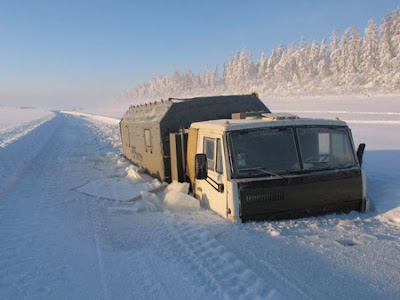
IN the coldest village on Earth, eyelashes freeze, dinner is frozen and temperatures sink to -88F


IN this remote outpost in Siberia, the cold is no small affair.Eyelashes freeze, frostbite is a constant danger and cars are usually kept running even when not being used, lest their batteries die in temperatures that average minus-58 degrees Fahrenheit in the winter, according to news reports.This is Oymyakon, a settlement of some 500 people in Russia’s Yakutia region, that has earned the reputation as the coldest permanently occupied human settlement in the world.It is not a reputation that has been won easily. Earlier this week, a cold snap sent temperatures plunging toward record lows, with reports as extreme as minus-88 degrees Fahrenheit.The village recorded an all-time low of minus-98 degrees in 2013.Though schools in the area remain open as temperatures dip into the minus-40s, they were closed on Tuesday, the Associated Press reported.Dark 21 hours a day in the winter, the town has been an object of international curiosity as its reputation for fearsome cold and the resilient residents who withstand it year after year, has grown.Amos Chapple, a photojournalist from New Zealand, traveled to the region in 2015 to capture the subzero way of life. The village is remote, located closer to the Arctic Circle than to the nearest major city, some 500 miles away, and Chapple described an arduous trip to get there to The Washington Post. After a seven-hour flight from Moscow, some 3,300 miles away, he took a van to a nearby gas station and then hitched a ride to the village after two days waiting in a shack and living off reindeer soup.
“After the first couple of days I was physically wrecked just from strolling around the streets for a few hours,” he said.The harsh cold climate permeates nearly every aspect of existence for the people who live in the area.
The winter diet is mostly meat-based, sometimes eaten raw or frozen, due to the inability to grow crops in the frigid temperatures. Some regional specialties include stroganina, which is raw, long-sliced frozen fish; reindeer meat; raw, frozen horse liver, and ice cubes of horse blood with macaroni,
In this photo taken on Jan. 14, Anastasia Gruzdeva poses for selfie as the temperature dropped to about -58 degrees Fahrenheit in Yakutsk, Russia.

Video taken during the cold snap showed a market, open for business on the snowy tundra, frozen fish standing rigidly upright in buckets and boxes, no refrigeration needed.
Customers in heavy winter clothing walked by, one with a child in tow. The narrator said it was minus-56 degrees.
“Here is the treasure,” the video’s narrator said of the whitefish used to make stroganina. He admitted he was getting a bit cold shooting the video.
“While filming the trading rows my hands froze to wild pain. And sellers stand here all day long. How do they warm themselves?” he said, according to the Siberian Times.
The village was once a stopover in the 1920s and ’30s for reindeer herders who would water their flocks at a thermal spring that didn’t freeze. Bathrooms are mostly outhouses; the ground is too frozen for pipes. According to the Weather Channel, the ground has to be warmed with a bonfire to break into, such as for digging a grave.


Gilgit Baltistan Part 2

Gilgit Baltistan Part 2

Government of Gilgit-Baltistan
The territory of present-day Gilgit-Baltistan became a separate administrative unit in 1970 under the name "Northern Areas". It was formed by the amalgamation of the former Gilgit Agency, the Baltistan District of the Ladakh Wazarat and the hill states of Hunza and Nagar. It presently consists of ten districts, has a population approaching one million and an area of approximately 28,000 square miles (73,000 km2), and shares borders with Pakistan, China, Afghanistan, and India. In 1993, an attempt was made by the High Court of Azad Jammu and Kashmir to annex Gilgit-Baltistan but was quashed by the Supreme Court of Pakistan after protests by the locals of Gilgit-Baltistan, who feared domination by the Kashmiris.

Government of Pakistan abolished State Subject Rule in Gilgit-Baltistan in 1974, which resulted in demographic changes in the territory.While administratively controlled by Pakistan since the First Kashmir War, Gilgit-Baltistan has never been formally integrated into the Pakistani state and does not participate in Pakistan's constitutional political affairs. On 29 August 2009, the Gilgit-Baltistan Empowerment and Self-Governance Order 2009, was passed by the Pakistani cabinet and later signed by the then President of Pakistan Asif Ali Zardari. The order granted self-rule to the people of Gilgit-Baltistan, by creating, among other things, an elected Gilgit-Baltistan Legislative Assembly and Gilgit-Baltistan Council. Gilgit-Baltistan thus gained a de facto province-like status without constitutionally becoming part of Pakistan. Currently Gilgit-Baltistan is neither a province nor a state. It has a semi-provincial status. Officially, the Pakistan government has rejected Gilgit-Baltistani calls for integration with Pakistan on the grounds that it would jeopardise its demands for the whole Kashmir issue to be resolved according to UN resolutions. Some Kashmiri nationalist groups, such as the Jammu and Kashmir Liberation Front, claim Gilgit-Baltistan as part of a future independent state to match what existed in 1947. India, on the other hand, maintains that Gilgit-Baltistan is a part of the former princely state of Jammu and Kashmir that is "an integral part of the country [India]
Regions
Gilgit-Baltistan is administratively divided into three divisions which, in turn, are divided into ten districts, consisting of the four Baltistan districts of Skardu, Shigar, Kharmang, and Ghanche, and the four Gilgit districts of Gilgit, Ghizer, Hunza and Nagarand two districts of Diamer and Astore are part of Diamer Division.The principal administrative centers are the towns of Gilgit and Skardu.


                                     Map of Gilgit-Baltistan,
 showing the boundaries of six of the ten present districts and their tehsils. The boundary between the recently created Hunza and Nagar districts and the now smaller Gilgit District is the same line as the northern boundary of the former Gilgit tehsil. That tehsil appears as the southernmost division of the area shown above in light blue. Aliabad, the administrative center of the new Hunza and Nagar Districts, is not yet shown on this map. Note: An up-to-date map showing the boundaries of all nine of the present districts is sorely needed.
Climate
The climate of Gilgit-Baltistan varies from region to region, surrounding mountain ranges creates sharp variations in weather. The eastern part has the moist zone of the western Himalayas, but going toward Karakoram and Hindu Kush, the climate dries considerably.

There are towns like Gilgit and Chilas that are very hot during the day in summer yet cold at night and valleys like Astore, Khaplu, Yasin, Hunza, and Nagar, where the temperatures are cold even in summer.
Mountaineering
Gilgit-Baltistan is home to more than 20 peaks of over 20,000 feet (6,100 m), including K-2 the second highest mountain on Earth.[112] Other well known peaks include Masherbrum (also known as K1), Broad Peak, Hidden Peak, Gasherbrum II, Gasherbrum IV, and Chogolisa, situated in Khaplu Valley. The 


                        Gilgit Baltistan Mountain Picture Gallery

                                           Chogolisa seen from the shoulder of K2

Nanga Parbat from the air: Diamir (west) face. In the background left of Nanga Parbat some peaks of the Karakorams: Saltoro Kangri, K6 and probably Sherpi Kangri(?) (right to left)

                             Masherbrum (Baltoro Glacier Area, Central Karakoram, Pakistan)

                                                          Hidden Peak (Gasherbrum I)

                                                                          Gasherbrum2
                              ATR 42-500 on Gilgit Airport. Picture taken on July 10, 2016

Neelam Valley in Pakistan

Neelam Valley in Pakistan

The Neelam River was known before Partition as Kishan Ganga and was subsequently renamed after the village of Neelam.[4] It flows down from the Gurez Valley in Indian Jammu and Kashmir and roughly follows first a western and then a south-western course until it joins the Jhelum River at Muzaffarabad. The valley is a thickly wooded region with an elevation ranging between 4,000 feet (1,200 m) and 7,500 feet (2,300 m), the mountain peaks on either side reaching 17,000 feet (5,200 m).
Most of the valley is taken up the Neelam Valley District(Urdu: ضلع وادی نیلم‬‎). The district is bordered on the south-west by Muzaffarabad District, which also encompasses the lower reaches of the valley, to the north-west beyond the mountains lies the Kaghan Valley in Khyber Pakhtunkhwa's Mansehra District, to the north and north-east are the Diamer, Astore and Skardu districts of Gilgit-Baltistan. To the south and east are the Kupwara and Bandipora districts of Indian Kahsmir. The Line of Control runs through the valley – either across the mountains to the south-east, or in places right along the river, with several villages on the left bank falling on the Indian side of the border.


Tourist attractions include:


Arang Kel
Athmuqam
Chitta Katha Lake
Dowarian
Ratti Gali Lake[19]
Halmat
Kel
Keran
Kutton
Sharda
Taobat
Sub-Valleys in the Neelum Valley
Neelum Valley has three sub-valleys within itself, These are
Leswa Valley
Jagran Valley
Babboon Valley
Shounter Valley
Salkhala Valley
Jagran sub-valley can be accessed from Kundalshahi. Babboon sub-valley can be accessed from Upper Neelum. Shounter Valley can be accessed from Kel

Neelum Valley Picture Gallery


                                                               Map Of Pakistan
Gilgit Baltistan Part 1

Gilgit Baltistan Part 1


Gilgit-Baltistan (Urdu: گلگت بلتستان‬‎), formerly known as the Northern Areas, is the northernmost administrative territory in Pakistan.It borders Azad Kashmir to the south, the province of Khyber Pakhtunkhwa to the west, the Wakhan Corridor of Afghanistan to the north, the Xinjiang region of China, to the east and northeast, and the Indian-administered state of Jammu and Kashmir to the southeast. According to UNSC Resolution of 1947 the territory is part of the disputed Kashmir region along with Azad Kashmir, Aksai Chin, the Shaksgam Valley, and Jammu, Ladakh, and the Valley of Kashmir.
The territory of present-day Gilgit-Baltistan became a separate administrative unit in 1970 under the name "Northern Areas". It was formed by the amalgamation of the former Gilgit Agency, the Baltistan district and several small former princely states, the larger of which being Hunza and Nagar. In 2009, it was granted limited autonomy and renamed to Gilgit-Baltistan via the Self-Governance Order signed by Pakistan president Asif Ali Zardari, which also aimed to empower the people of Gilgit-Baltistan. However, scholars state that the real power rests with the governor and not with chief minister or elected assembly. The population of Gilgit-Baltistan wants to be merged into Pakistan as a separate fifth province and opposes integration with Kashmir.The Pakistani government has rejected Gilgit-Baltistani calls for integration with Pakistan on the grounds that it would jeopardise its demands for the whole Kashmir issue to be resolved according to UN resolutions.
Gilgit-Baltistan covers an area of over 72,971 km² (28,174 sq mi) and is highly mountainous. It had an estimated population of 1,800,000 in 2015.[2] Its capital city is Gilgit (population 216,760 est). Gilgit-Baltistan is home to five of the "eight-thousanders" and to more than fifty peaks above 7,000 metres (23,000 ft). Three of the world's longest glaciers outside the polar regions are found in Gilgit-Baltistan. Tourism is mostly in trekking and mountaineering, and this industry is growing in importance.

Gilgit Baltistan Pictuer Gallery
             Aqua Ambulance on Attabad Lake Hunza GilgitBaltistan.

bzo is its local name in balti and is type of bull located in skardu baltistan

                                                                                  K2 August 2006


Rays of the summer sun setting reflected on the Passu mountains also known as the Passu cathedrals

Upper Kachura Lake

   Cold Desert of Skardu, Gilgit Baltistan, Pakistan

                                                                               Shangrila Lake, Skardu

                                                                       Yak polo match in Barogil Festival.
 
Copyright © 2015. Waqas4s
Blogger Templates